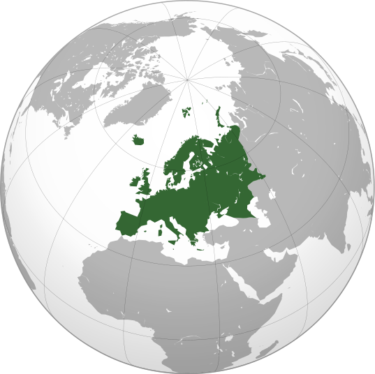
Imajen:Europe orthographic Caucasus Urals boundary.svg

Dimensões desta antevisão em PNG do ficheiro SVG: 537 × 536 píxeis Outras resoluções: 240 × 240 píxeis | 481 × 480 píxeis | 769 × 768 píxeis | 1 026 × 1 024 píxeis | 2 052 × 2 048 píxeis.
Fixeiru original (ficheiro SVG, de 537 × 536 píxeis, tamanho: 77 KB)
Histórico do ficheiro
Clique uma data e hora para ver o ficheiro tal como ele se encontrava nessa altura.
| Loron/Tempu | Miniatura | Dimensões | Uza-na'in | Komentáriu | |
|---|---|---|---|---|---|
| atuál | 13h32min de 4 de Setembru de 2022 |  | 537 × 536 (77 KB) | M.Bitton | Reverted to version as of 12:03, 4 September 2022 (UTC): per COM:OVERWRITE |
| 13h30min de 4 de Setembru de 2022 |  | 537 × 536 (177 KB) | Рагин1987 | Small correction | |
| 12h03min de 4 de Setembru de 2022 |  | 537 × 536 (77 KB) | M.Bitton | Reverted to version as of 05:48, 12 March 2019 (UTC): per COM:OVERWRITE + fake svg | |
| 19h12min de 30 de Agostu de 2022 |  | 2 052 × 2 048 (874 KB) | Рагин1987 | More correct visualization of the dividing line on the territory of the Caucasus Range | |
| 05h48min de 12 de Marsu de 2019 |  | 537 × 536 (77 KB) | AndreyKva | Optimized. | |
| 19h25min de 3 de Marsu de 2016 |  | 537 × 536 (197 KB) | Denniss | Reverted to version as of 13:27, 19 October 2014 (UTC) | |
| 18h37min de 3 de Marsu de 2016 |  | 537 × 536 (239 KB) | Ercwlff | UC UC UC | |
| 13h27min de 19 de Outubru de 2014 |  | 537 × 536 (197 KB) | Deni Mataev | Again, The entirety of Georgia is not in Europe geographically, only North Eastern parts are | |
| 20h05min de 18 de Outubru de 2014 |  | 537 × 536 (238 KB) | Politologia | Reverted to version as of 10:57, 18 October 2014 In all maps Georgia is part of Georgia. There is at list 10 versions of borders of Europe in most of them Georgia is part of Europa | |
| 20h04min de 18 de Outubru de 2014 |  | 537 × 536 (238 KB) | Politologia | Reverted to version as of 10:57, 18 October 2014 In all maps Georgia is part of Georgia. |
Pájina iha ne'ebá fixeiru ne'e
A seguinte página usa este ficheiro:
Utilização global do ficheiro
As seguintes wikis usam este ficheiro:
- Uso no domínio ab.wikipedia.org
- Uso no domínio ace.wikipedia.org
- Uso no domínio ady.wikipedia.org
- Uso no domínio af.wikipedia.org
- Uso no domínio ar.wikipedia.org
- بوابة:آسيا
- بوابة:أوروبا
- بوابة:إفريقيا
- بوابة:القارة القطبية الجنوبية
- بوابة:القارة القطبية الجنوبية/بوابات شقيقة
- قائمة جوازات السفر
- بوابة:تركيا
- بوابة:تركيا/بوابات شقيقة
- بوابة:جغرافيا/مقالة مختارة/أرشيف
- المرأة في تركيا
- بوابة:أوروبا/واجهة
- بوابة:تصفح
- بوابة:تصفح/جغرافيا
- قائمة مفاتيح الاتصال الدولية
- المرأة في ألمانيا
- بوابة:إسطنبول
- بوابة:آسيا/بوابات شقيقة
- ويكيبيديا:مقالة الصفحة الرئيسية المختارة/398
- بوابة:جغرافيا/مقالة مختارة/21
- معاملة المثليين في أوروبا
- المرأة في أوروبا
- المرأة في البرتغال
- المرأة في فنلندا
- المرأة في مقدونيا الشمالية
- المرأة في ترانسنيستريا
- المرأة في الفاتيكان
- المرأة في أذربيجان
- المرأة في اليونان
- المرأة في ألبانيا
- المرأة في إيطاليا
- المرأة في الجبل الأسود
Ver mais utilizações globais deste ficheiro.


